NH Zoning Atlas offers groundbreaking insight into local building restrictions

In 2021, we published a landmark study that showed how local land use regulations drove New Hampshire’s housing shortage. That study changed the conversation on affordable housing in New Hampshire, from one focused on government subsidies to one focused on regulations. This week, the Center for Ethics in Society at Saint Anselm College set the next housing policy landmark when it released the New Hampshire Housing Atlas.
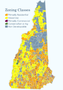 The New Hampshire Zoning Atlas is the most powerful tool Granite Staters have ever had for understanding local zoning ordinances. It catalogues—and maps—23,000 pages of zoning regulations in 2,139 districts in 269 jurisdictions. Never has this information been available in one place, much less open for public examination.
In the atlas, users can quickly find the building and land use restrictions in one community, or search the state to see what restrictions are in effect across multiple communities. The search tool and maps reveal just how severely New Hampshire municipalities have restricted people’s housing options, and how much freer some towns are than others.
The atlas shows that single-family homes are allowed by right on 90% of New Hampshire’s buildable land, and by public hearing on another 6%. Sounds good, right?
A closer look, though reveals that single family homes on lots of less than one acre are illegal—yes, literally illegal—on most of that property. It is legal to build a home on less than one acre in only 16% of the state’s buildable land.
You might think of zoning as “allowing” certain types of property uses. In reality, zoning is a prohibition. It carves communities into areas in which most uses of private property are outlawed. Large minimum lot size requirements are the perfect example of a regulation that outlaws a once common housing preference. The result is a nearly statewide prohibition on the construction of affordable starter homes.
People generally have no problem with municipalities using zoning to, say, keep industrial operations out of residential neighborhoods. The New Hampshire Zoning Atlas shows, however, that municipalities commonly use this power to outlaw small yards, duplexes, apartments and any mixing of commercial and residential activities. The maps show that it isn’t unusual for municipalities to take zoning restrictions to absurd extremes.
Lebanon’s rural lands 3 zone has a huge 10-acre minimum lot size for single-family homes, which we knew from previous research. But the atlas shows that Hanover isn’t alone. Meredith’s forest and conservation district also has a 10-acre minimum lot size. Marlowe’s rural lands district has a minimum lot size of 20 acres!
Neighboring towns can have huge discrepancies in the types of homes they allow.
No portion of Bedford, Merrimack or New Boston has a minimum lot size of five acres or more. But significant portions of Mont Vernon and Amherst do. Two-family housing is allowed in most of Londonderry, but in only a small sliver of Derry.
Though the New Hampshire Zoning Atlas is itself policy neutral (it’s just a presentation of data), it’s likely to lead to policy changes. It’s hard to justify zoning that allows rental housing of five units or more, but bans duplexes and triplexes, for example. This particular rule shows up in a surprising number of communities.
The atlas offers an invaluable tool for citizens who want to better understand how government regulations prevent the market from providing housing options that people want, even in times of sky-high demand.

